



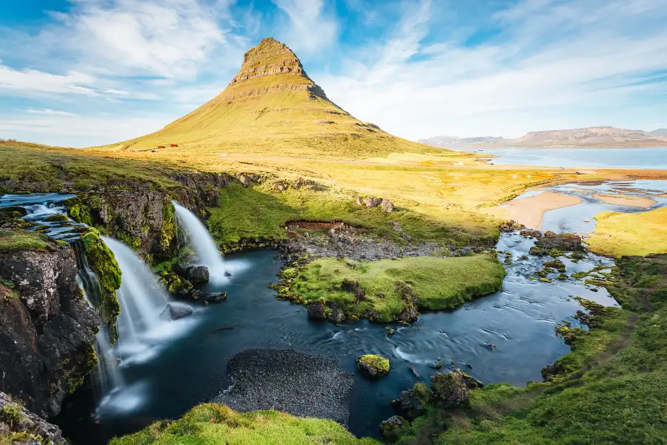
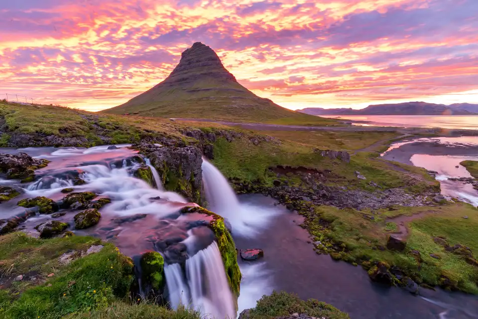
Kirkjufell (“Church Mountain”) is Iceland’s most-photographed mountain — a 463-metre arrowhead rising from the sea-edge pastures of the Snæfellsnes peninsula, with the three-step Kirkjufellfoss and its pond in the foreground completing the most famous composition in the country. The formula exists because it works: mountain, waterfall, mirror reflection — and at sunrise or sunset, in calm weather, it looks like the postcards. Trip.Best ranks it #15 (4.6/5 verified).
This is #15 of 39 in our Best Things to Do in Iceland guide. Below: the classic composition and where exactly to stand, the light logic, the Game of Thrones connection, the short hiking option, and how the mountain anchors the Snæfellsnes loop — Iceland’s “miniature country” day-drive.
Key takeaways
- 463 m of geometry: a glacially-carved horn that reads as an arrowhead — or, in Game of Thrones season 6, as the “arrowhead mountain” north of the Wall.
- The pond is the shot: the small tarn beside Kirkjufellfoss doubles the mountain in calm conditions — the classic frame everyone came for.
- Sunrise and sunset: the appointments; the mountain faces the light sideways and the pond needs windless hours.
- Climbable, with a guide: the summit route is roped-season hiking — guided parties only; most visitors photograph rather than climb.
- Free, road-side: the viewing area and waterfall sit right off Route 54 with paid parking.
Quick answer: Arrive inside the sunrise or sunset window (check the calm forecast — the pond reflection is the whole composition), shoot the classic from the pond bank with the three-step fall in frame, then walk the 15-minute waterfall circuit and the roadside angles. The mountain anchors the Snæfellsnes loop: black-pebble coves west, the glacier cone, and the fishing villages around the peninsula.
The classic composition
The famous frame is a triangle: Kirkjufell behind, the three-tiered Kirkjufellfoss mid-ground, and the pond in front doubling everything. The viewing area manages this composition officially — boardwalks and marked banks around the pond, paid parking beside Route 54, and a 15-minute loop past the fall’s tiers. In flat calm, the mirror works; in wind, the pond ripples and the composition degrades to the waterfall-and-mountain version, which is still excellent.
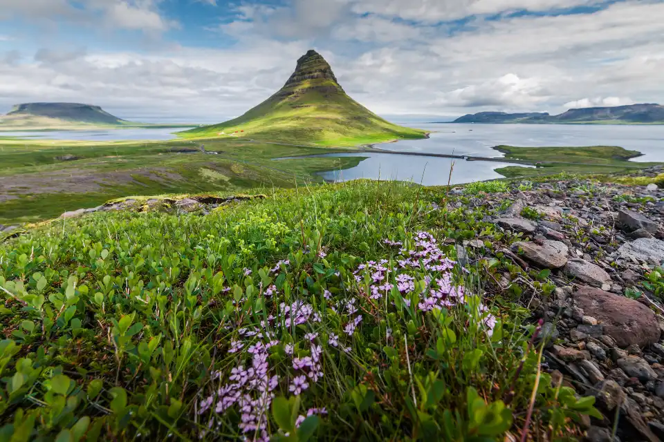
The mountain itself is the subject: a perfect glacial horn — carved by ice from all sides into the arrowhead silhouette that GoT fans recognise from season 6 (the “mountain shaped like an arrowhead” beyond the Wall; the production shot the surrounding peninsula too). The geology story explains the shape; the photography explains the fame; the location — rising straight from sea-level pasture with fishing village Grundarfjörður at its foot — explains why every angle works.
Why the pond matters: the tarn is a groundwater pool, not a river pool — it goes glassy in calm weather and stays messy in wind. The forecast’s wind speed matters more than cloud here; a gray windless evening outperforms a blue-sky gale.
The light and the frames beyond the classic
Sunrise and sunset are the appointments — the low sun rakes the mountain’s flanks and the pond mirror needs exactly the golden-hour calm. Aurora season adds the north-facing bonus: the cone faces north across the bay, so displays sit behind or above the peak — the Kirkjufell-under-aurora shot is one of Iceland’s signature frames and the reason photographers winter here. The photography guide’s Kirkjufell chapter carries the full workflow (filters, positions, the aurora recipe).
Beyond the classic: the fall’s own three tiers shoot individually; the roadside north angle puts the mountain over Grundarfjörður’s harbour; the drive east along Route 54 gives the mountain-over-sea frames. Winter: the mountain ices, the pond freezes at its edges, and the whole composition goes white-on-black — a legitimate second season for the same shot.
The calm-window play: watch the wind forecast, not the cloud forecast. Kirkjufell photographs best on still evenings whatever the sky — gray calm beats blue wind every time. en.vedur.is hourly wind maps decide the trip out west.
Practical: access, hiking and the village
Access is road-side: the viewing area and car park sit between Grundarfjörður and the fall, 2.5 hours from Reykjavík via Route 54 (winter: check the road status — Snæfellsnes roads hold well but wind closes them occasionally). Facilities are minimal at the site (toilets seasonally); the village carries cafés, fuel and accommodation — Grundarfjörður is the loop’s natural overnight.
Hiking: the short circuit (fall + banks, 15–30 min) is the standard. The summit route exists — a roped, guided-season climb via the east face — but it is a guided-party activity, not a wander-up; treat the mountain as a photograph unless you book the climb. Drones: national rules, site signage, and the crowd factor on summer evenings.
How it fits an Iceland route
Kirkjufell is the northern anchor of the Snæfellsnes loop (#37’s glacier at the peninsula’s west end): black-pebble coves (Djúpalónssandur), the lava cliffs at Arnarstapi–Hellnar, the Snæfellsjökull cone, and the fishing villages — one day drives it all, Kirkjufell is the overnight reward. From the capital: 2.5 hours each way, or the full loop as a two-day west trip. Our Snæfellsnes guide maps the peninsula, and the photography guide’s chapter covers the mountain in depth.
Frequently asked questions
Where do you take the famous Kirkjufell photo?
From the pond bank in the designated viewing area beside Route 54 — mountain behind, three-step waterfall mid-ground, pond reflection in front. The area is managed with boardwalks; tripod space is first-come at golden hour.
Can you climb Kirkjufell?
Only with a guide — the summit route is a roped, seasonal climb offered by local operators. Most visitors photograph it instead; the classic compositions need no hiking at all.
When is the best time to photograph Kirkjufell?
Windless sunrise or sunset, any season — calm matters more than sky. September–March adds the aurora-behind-the-peak option on clear nights; the pond goes glassy only when the wind drops.
Why is Kirkjufell famous?
Two reasons: the most-photographed-mountain composition (fall, pond, arrowhead peak), and Game of Thrones season 6, which used it as the arrowhead mountain beyond the Wall. Both brought the world to Grundarfjörður.
Where this ranks — and what is next
Kirkjufell is #15 of 39 in our Best Things to Do in Iceland guide — the full ranked list, built from Trip.Best traveler data, lives in one place.
Go deeper: Snæfellsnes — Iceland in miniature (the full peninsula), How to photograph Kirkjufell (spot 1 of 20).
Sources & official references
- Trip.com listing for Kirkjufell: 4.6/5 rating (checked November 2026).
- Trip.Best ranking data: #15 of 39 (November 2026).
- Site operator information: parking, viewing-area management (checked 2026).
- Game of Thrones filming-location records (Snæfellsnes, season 6).
- Editorial visits across seasons including aurora sessions, 2023–2026.
