









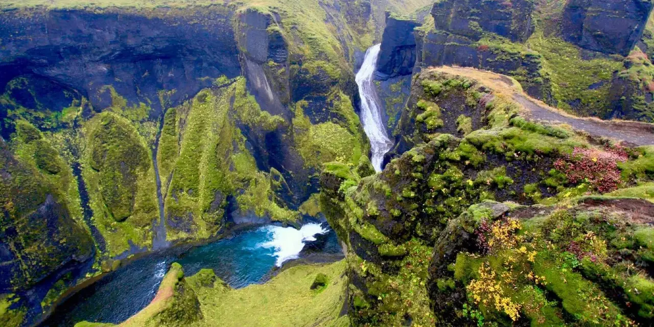
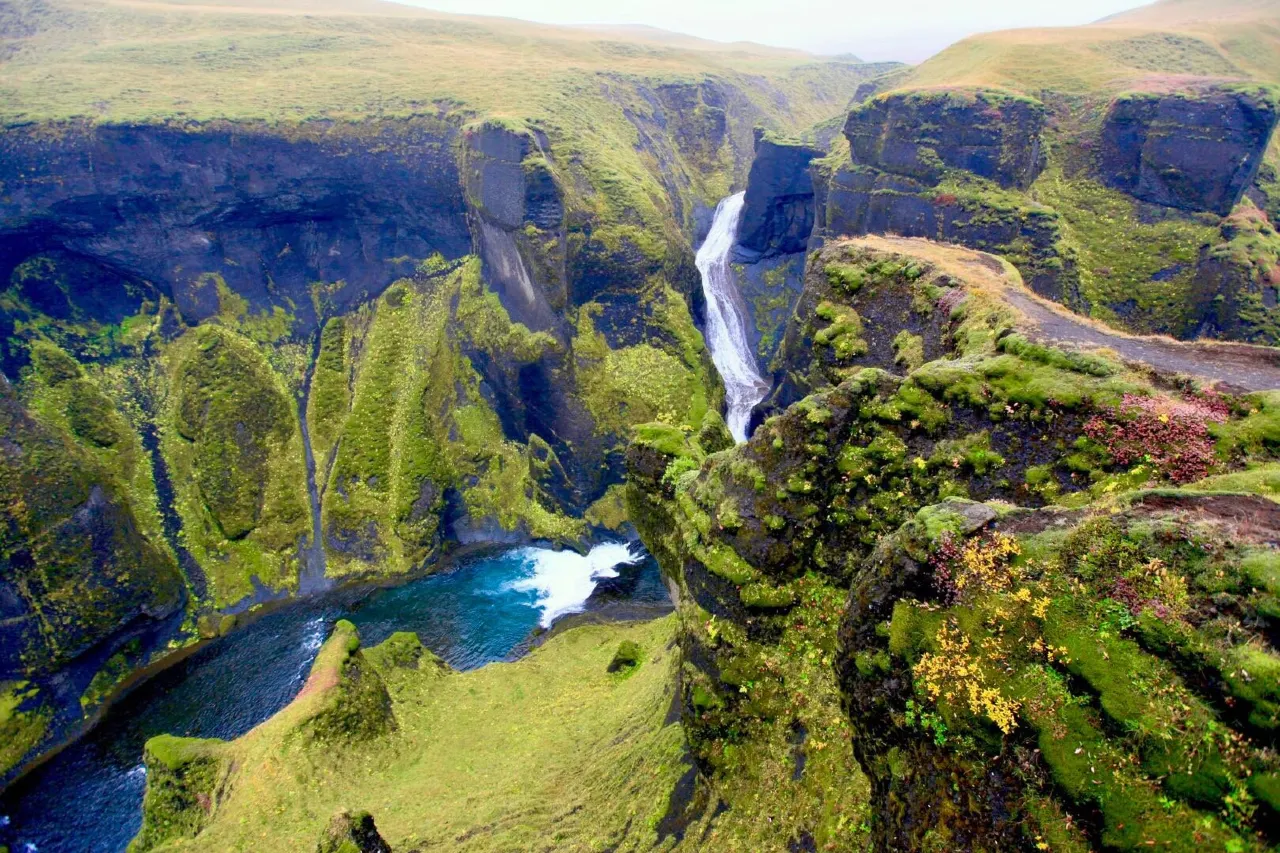
This is spot 18 of 20 in our Iceland Photography Guide — the green canyon. Fjaðrárgljúfur, two kilometres of moss-walled canyon carved up to roughly 100 metres deep by the Fjaðrá river near Kirkjubæjarklaustur, is the master list’s south-coast secret: less famous than the falls it sits between, and the most three-dimensional landscape on the list — the field tip says it directly: “the rim walk layers the mossy canyon walls; stay on marked paths.” The rim trail layers the serpentine river, the moss cliffs and the serried canyon turns into compositions no other master-list spot produces.
The canyon is also the list’s conservation story: it closed temporarily in 2019 after visitor numbers damaged the fragile moss (the viral music-video moment did not help), reopened with managed paths, and its “stay on marked paths” rule is the ecology, not just etiquette. This guide covers access, the rim-walk compositions, the afternoon side-light the master list calls, the seasons, and the path discipline that keeps this canyon open.
Key takeaways
- The rim walk is the composition: each bend has a viewpoint — the walk produces a sequence of layered frames, not one hero shot.
- Afternoon side light: the master list’s pick — the west-facing walls catch warm light that models the serpentine; gray days flatten the river but keep the moss.
- Stay on marked paths: the moss is fragile and the canyon’s ecology depends on the managed trail — the master tip is conservation here, not just safety.
- Long lens for the serpentine: 70–200 mm compresses the river’s S-curves between the walls; 16–35 mm gives the rim’s scale frames.
- Pairs with the Eldhraun moss desert: the Laki eruption’s moss-covered lava field lies twenty minutes west — the canyon’s green context and a worthy second stop.
Quick answer: park below the canyon (signed off the Ring Road near Kirkjubæjarklaustur), walk the marked rim trail clockwise, and shoot each bend’s viewpoint as you go — long lens for the serpentine layers, wide for the scale frames. Come in the afternoon for the master list’s side-light or in gray for the moss. Ninety minutes covers the full rim; add the Eldhraun moss desert on the way west.
Access and the rim walk
The canyon sits west of Kirkjubæjarklaustur on the Ring Road’s southern stretch — signed parking below the canyon mouth, a café in season, and the marked rim trail climbing from the lot. The walk is easy (gravel and stone steps, roughly forty-five minutes for the full loop with camera stops), and the master tip’s phrase is the operating manual: the rim walk layers the walls — each bend’s viewpoint adds the river’s next curve behind the last. The trail’s high point looks down the full serpentine; the low points put you nearly level with the river.
The 2019 closure and reopening shaped today’s access: fencing along the rim edges, wooden view platforms at the key bends, and enforced path discipline — the marked trail is the only legal surface, and the platforms are the only rim-edge positions. This is less restrictive than it sounds: the platforms sit exactly where the compositions are, and the fence is usually out of frame or usable as a foreground line.
Access runs year-round; winter adds ice to the rim (traction matters) and can partially close sections — signage rules, as always.
Compositions that work
The canyon is a layered-frame machine — four setups cover the sequence:
- The serpentine compression: from the upper viewpoints, 70–200 mm — the river’s S-curves stacked between the moss walls, compressed into one graphic line. This is Fjaðrárgljúfur’s signature and the frame the rim exists to deliver.
- The scale rim: 16–35 mm from the platforms — the canyon’s depth with the river small below, a hiker on the far path for scale. The “how deep is that” frame.
- The moss close: the walls’ textures at 50–100 mm — moss hummocks, water streaks, the green-on-green study. Gray light is the moss’s best light.
- The water level: where the trail approaches the river, low-angle frames along the current between the walls — 1–4 s, tripod, the canyon from inside. The master archive’s “Fjaðrá curling along the canyon floor” genre.
Weather interplay: the canyon photographs in fog (the walls fade in layers — an automatic depth-of-field effect), in clearing storm light (spot sun on one bend at a time), and in the master list’s afternoon rake. It never fully fails; the fog version alone justifies a wet drive.
Afternoon side light and the gray alternative
The master list gives Fjaðrárgljúfur “afternoon side light,” and the geometry delivers: the canyon runs roughly north-south with its west-facing walls catching the afternoon sun’s warm rake — the light models each bend, warms the moss, and throws the river’s curves into relief. The window runs from early afternoon (summer) or mid-afternoon (shoulder seasons) until the sun drops behind the rim. Morning is the canyon’s shade hour: cool, green, moody — a legitimate alternative genre rather than a failure.
Gray days flatten the serpentine but saturate the moss — the texture study thrives, and fog turns the canyon into the layered-depth study described above. The en.vedur.is clock picks the genre; the canyon rewards all three (sun-rake, gray-moss, fog-layers) at different hours of the same day.
Settings and technique
The serpentine frames run f/8–f/11, ISO 64–100, tripod where the platforms allow (they are narrow — brace and shoot hand-held at 1/60 s+ when they are busy). Polarizer: on for the moss and the wet rock, off when shooting into the afternoon rake (the light is the subject). Exposure for the green: the moss’s dark saturation drags the meter up — a -0.3 EV habit and RAW keep the greens honest.
Water frames at the river level run the standard 1–4 s tripod discipline; the moss close-ups want f/8 and the polarizer rotated to kill leaf glare. One kit note: the rim’s wind funnels — the master guide’s tripod-anchoring rule applies at the open viewpoints.
The path rule is the ecology
The master tip’s “stay on marked paths” carries extra weight here because the canyon already proved its fragility: the 2019 closure happened after the moss — which grows millimetres per year — was trampled past recovery by off-path traffic. The reopened canyon runs on the managed-path system, and the photographer’s role is simple: every frame from the marked surfaces, drones per the national baseline and site rules (check signage; the canyon’s airspace is narrow), and no “just one step over” anywhere. The responsible travel guide covers the logic that keeps the whole island photographable.
Seasons and the south-east chain
The canyon photographs year-round: summer gives the deepest greens and the longest rake; September adds the first gold birches to the moss; winter rims the walls with ice and empties the platforms; spring is the moss’s brightest green after thaw. The master list’s afternoon-light pick works in every season that the sun’s arc allows.
The chain context: Fjaðrárgljúfur sits between the south coast’s falls and the southeast triangle — Reynisfjara Und Skógafoss to the west, Jökulsárlón Und Diamond Beach to the east. It is the natural mid-morning stop on any southeast day, and the complete canyon guide covers the Eldhraun pairing and the Kirkjubæjarklaustur base in detail.
Frequently asked questions
Why did the canyon close in 2019?
Visitor numbers — amplified by a viral music video — trampled the fragile moss past recovery, and the site closed temporarily to let it rest. It reopened with managed paths and platforms; the master tip’s “stay on marked paths” is the lesson the closure taught, and the ecology it protects.
Which lens dominates here?
The long zoom for the serpentine compressions (the signature frame) and the wide for the scale rims — Fjaðrárgljúfur is the list’s clearest two-lens canyon. The moss close-ups slot between them; bring both if the pack allows.
Is the fog version worth a wet drive?
Yes — fog layers the canyon walls into automatic depth: the nearest wall sharp, each bend behind fading. It is the composition that most efficiently communicates the canyon’s depth, and south-coast fog is common enough that the genre repeats. The en.vedur.is visibility fields call it.
How long should the stop take?
Ninety minutes covers the full rim walk with camera stops at the platforms; add the river-level frames and the Eldhraun detour and the stop becomes a half-day. In the master list’s geography it slots mid-morning on any southeast day.
The full field list lives in one place
Spot 18 of 20 — the master guide ranks all twenty locations by region, best light and a field tip for each.
Go deeper: the complete Fjaðrárgljúfur guide, the responsible travel guide behind the path rules, and the Ring Road guide for the southeast sequencing.
Sources & official references
- Canyon dimensions (~2 km long, ~100 m deep) per published survey figures and site interpretation materials.
- 2019 closure and managed reopening: published reporting and site management information (checked 2026).
- Path rules and drone signage: on-site information; the marked trail is the only legal surface.
- Weather and fog windows: en.vedur.is forecasts for the southeast.
- Editorial photography trips across seasons 2022–2026 by the Iceland Travel Guides team.
