







This is spot 10 of 20 in our Iceland Photography Guide — the rift where continents visibly drift apart. Þingvellir (Thingvellir) is the only master-list location that is simultaneously a geology subject (the Almannagjá gorge between the North American and Eurasian plates), a history subject (the Althing, founded around 930 AD, met on this plain for centuries and the site is UNESCO-listed), and a lake-and-cliff landscape (Þingvallavatn, Iceland’s largest natural lake, under the gorge walls). The master guide’s field tip — “the Almannagjá walls frame both sunrise and aurora” — is the composition key: the gorge does the framing for you, in every season and at both ends of the day.
Þingvellir is also the master list’s autumn-and-night pick (“autumn color, clear nights”), and it is the closest genuine dark-sky location to Reykjavík — forty minutes from the capital’s streetlights, a national park with legal aurora access and unobstructed northern horizons. This guide covers access, the gorge and rift compositions, the seasonal color windows, the aurora game, and how the park fits the Golden Circle chain.
Key takeaways
- The gorge frames everything: Almannagjá’s walls lead the eye to the visitor centre plateau; shoot along the rift, not just across it.
- Autumn is the color window: birch scrub turns gold and rust against dark basalt — the master list’s pick, and the park’s strongest color moment.
- Clear nights = legal aurora: the park is 40 minutes from Reykjavík with open northern horizons — the capital region’s default aurora location.
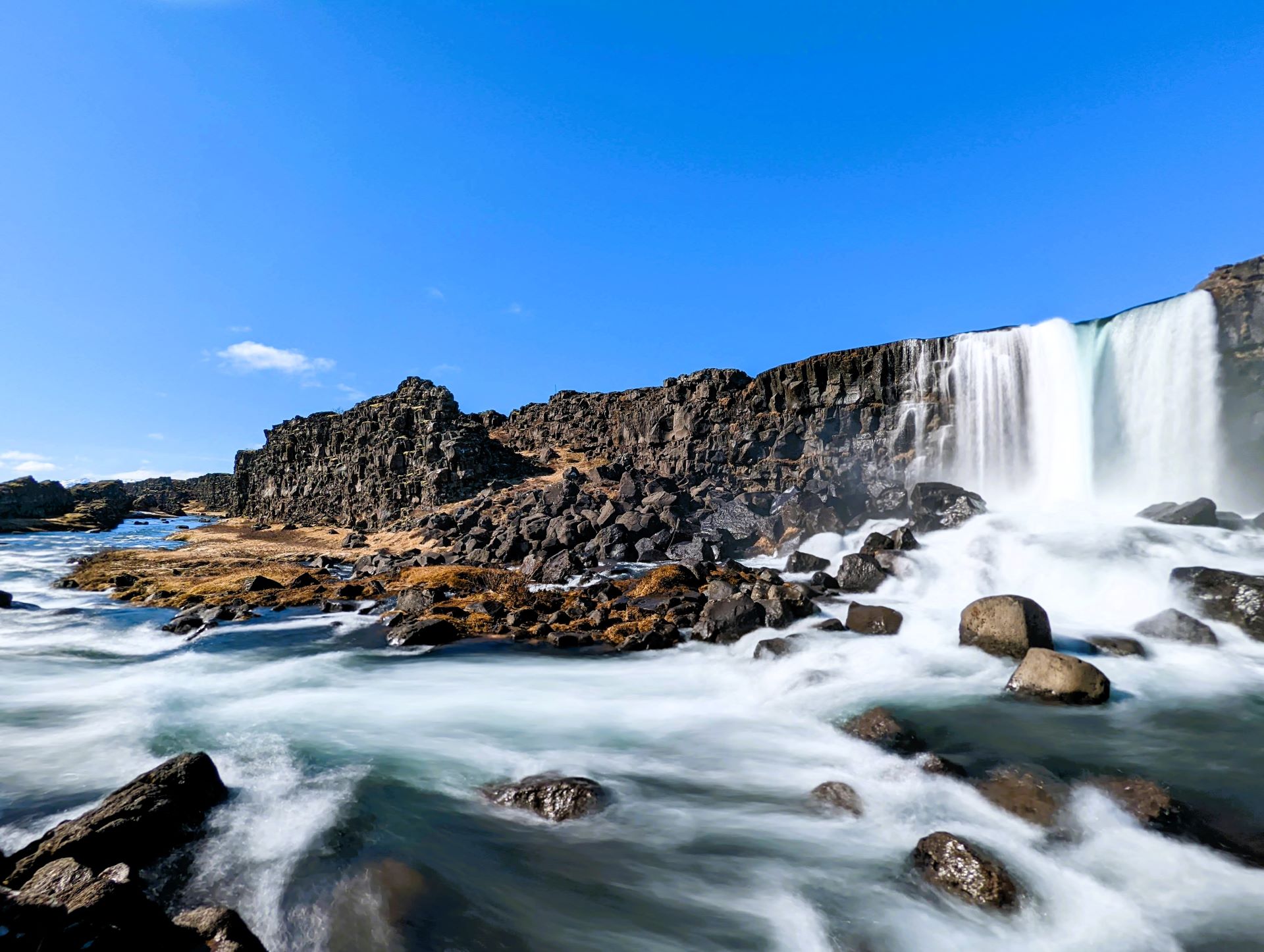
- Öxarárfoss is the bonus: the small waterfall dropping into the rift is a complete composition in itself, best in winter when it partially freezes.
- It is a UNESCO cultural site: photograph the meeting-plain history (the Law Rock, the flag) with the same seriousness as the geology.
Quick answer: park at the main Hakla lot, walk the Almannagjá boardwalk down the rift, and shoot the gorge-and-plateau frames along the way. Detour to Öxarárfoss on the loop, then continue to the church and meeting-plain for the history frames. Return after dark in autumn or winter for the aurora over the rift — the same path network, a different masterpiece.
Access and the park layout
Þingvellir National Park is forty minutes east of Reykjavík on Road 36, open year-round, with several paid car parks (pay by card or app), visitor centres, and a path network that covers the whole site in an hour. The core circuit: down the Almannagjá boardwalk (the rift floor between basalt walls), past Öxarárfoss where the Öxará river drops into the gorge, out onto the meeting plain toward the church and flagpole that mark the Althing site. Paths are flat and maintained in winter — this is the easiest master-list park to shoot in any season.
The park has photography-friendly rules: aurora and night photography are welcome, drones follow the national baseline (120 m, line of sight) but check park-specific signage — national-park permit logic applies here as the master guide’s drone section notes. The site is busiest 10:00–16:00 with coach traffic; photographers work the edges of those hours, and the aurora sessions after 22:00 share the paths with a few thousand stars instead.
The complete Þingvellir guide covers the park’s history and the Silfra fissure snorkeling story (the 100-metre-visibility glacial water that fills the rift — one of the world’s clearest dive sites); photographically, Silfra’s platform gives the see-into-the-crack frames from above.
Compositions that work
The rift is a leading line, a frame and a subject at once — the compositions pick which role it plays:
- The gorge corridor: shoot along Almannagjá — the boardwalk and the walls converging, visitors small in frame, the plateau ahead. 24–35 mm at eye height; the rift’s geometry does the drawing.
- The wall face: tight on the basalt wall’s cracked face with the fissure edge above — the continent boundary as texture. 50 mm+, side-light.
- Öxarárfoss: the river dropping into the rift between mossy walls — 16–35 mm, tripod, 1–4 s. Winter’s partial freeze is the standout version; autumn’s birch gold is second.
- The lake plain: Þingvallavatn and the islands under the mountain Skjaldbreiður’s silhouette — from the churchyard side at sunset. The history frames (flag, Law Rock, church) layer in here; the park photographs its parliament the way it photographs its geology.
- Silfra from above: the platform over the fissure — the water’s impossible clarity reads as the crack glowing blue-green. Polarizer off (that clarity is the subject), fast shutter.
Autumn color and the night sky
The master list’s “autumn color, clear nights” is the park’s photographic identity, and both halves are real. September–October turns the park’s birch scrub gold and rust; against the black basalt and the green moss this is the strongest color contrast any master-list location produces in that month — and the crowds of summer have gone. Gray days work (the color carries itself); clearing storms after rain are the standout sessions.
The night half is structural: Þingvellir sits far enough from Reykjavík’s light dome that genuine darkness returns, the northern horizon over the lake is unobstructed, and the park stays open and safe for night work. On clear nights from September to March, the aurora over Almannagjá’s walls is the frame the master guide’s field tip describes — the gorge as the foreground for the lights. The aurora guide and the master list’s wildcard entry (spot 20) carry the full recipe.
Winter layers the third genre: the park under snow, Öxarárfoss partially frozen, the gorge walls rimmed with ice — gray-light monochrome with the rift’s geometry intact.
Settings and technique
Daylight frames run standard park discipline: f/8–f/11, ISO 64–100, tripod for the waterfall work (1–4 s) and hand-held for the gorge walk. The basalt-vs-birch contrast is the exposure challenge — matrix metering handles it in RAW; protect the birch highlights at autumn sunset. The wall-face textures want side-light or nothing; front light flattens the rift’s depth exactly where its drama lives.
The aurora sessions run the master-list recipe with park-specific additions: compose the gorge walls (or the church silhouette) as the foreground before dark — manual focus set on their edges, positions marked. ISO 1600–3200, 8–15 s, f/2.8. The boardwalk lights off at night (the park goes genuinely dark) means headlamps with red mode; the paths are winter-maintained but ice patches persist — the same footing discipline as any winter park session.
The aurora game
Þingvellir is the reason the master guide’s aurora wildcard (spot 20) has a home base near the capital: forecast check on en.vedur.is (cloud cover + aurora activity), KP irrelevant-ish (Iceland sits under the auroral oval — activity “0” nights still show lights when the sky is clear), and the drive is forty minutes. Work the lake plain for open-sky frames or the gorge for the walls-and-lights composition. The park’s night sessions are legal, safe and quiet — arrive with positions scouted, leave the headlamp red, and give the lights the foreground they deserve.
Seasons and the Golden Circle chain
Every season photographs, with clear specializations: autumn owns the color (September’s gold against basalt), winter owns the frozen waterfall and the snow-mono, summer owns the green moss and the midnight light, spring owns the empty paths. The park is the Golden Circle’s first stop — pair per the master guide’s light logic: Þingvellir morning, Strokkur midday, Gullfoss afternoon, Þingvellir again after dark if the sky clears.
The Golden Circle route guide and the complete Þingvellir guide carry the full context; the aurora-in-Reykjavík guide frames the capital-side alternative for nights when the park is too far.
Frequently asked questions
Is Þingvellir good for aurora photography?
It is the capital region’s default aurora location — forty minutes from Reykjavík, genuinely dark, legally open at night, with the gorge walls and the lake as foregrounds. Check the en.vedur.is cloud forecast, arrive with positions scouted before dark, and run the master-list recipe (ISO 1600–3200, 8–15 s, manual focus).
When is the autumn color at its peak?
Mid-September through mid-October, weather-dependent — the birch scrub turns gold and rust against the basalt. The master list calls it the park’s window for a reason; gray days photograph beautifully because the color carries itself.
Can I photograph inside Silfra?
The platform above the fissure gives the see-into-the-water frames for free; actual underwater photography requires booking a snorkel or dive tour with a permit-holding operator — the water’s legendary clarity (100 m+ visibility) is the subject. The surface frames already read as impossible to most viewers.
How long should a photography session take?
Ninety minutes covers the gorge, Öxarárfoss and the history plain in daylight; add an evening return for aurora in season. The park rewards two visits in one day (daylight + night) more than one long one — the light windows are different genres, not different hours.
The full field list lives in one place
Spot 10 of 20 — the master guide ranks all twenty locations by region, best light and a field tip for each.
Go deeper: the complete Þingvellir guide, the aurora guide for the night recipe, and the Golden Circle guide for the full-circle logistics.
Sources & official references
- Park rules, parking and night access: Þingvellir National Park official information (checked 2026).
- UNESCO listing and Althing history: World Heritage Centre records; parliament founding circa 930 AD per published histories.
- Plate drift and Silfra clarity: published geological survey figures and park interpretation materials.
- Aurora forecasting: en.vedur.is cloud and aurora outlooks.
- Editorial photography trips across seasons 2022–2026 by the Iceland Travel Guides team.
